Sussex Scrapbook

Using a map and compass.
We're assuming that
you'll be using
Ordnance Survey Landranger maps or
Explorer Maps, which are easily available and have a scale of 1:50,000
and 1:25,000. These
maps give you an amazing amount of information and can not only show you the
position of places but can also tell you about the type of terrain, the altitude, the
incline, the way the land is used and even the history of the places. There are
of course many modern gadgets that can tell you your position and display it on
a map but they all need batteries to make them work and they can also be easily broken.
Why not learn to use a map and compass the old fashioned way so that the old-school method's always there as a back-up.
There's a lot of
symbols on an OS map and in time you'll learn to recognise most of them without
having to refer to the legend all the time. In the meantime, there are only a handful or so
that you need to familiarise yourself with straight away. The following are all
used on the 1:50,000 maps but we suggest you also learn the symbols on the
1:25,000 maps too as they are slightly different.
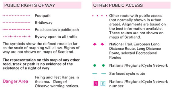
Take note: Footpaths are for feet - not for bikes. If you're on a bike then you
must use bridleways and other rights of way intended for them.
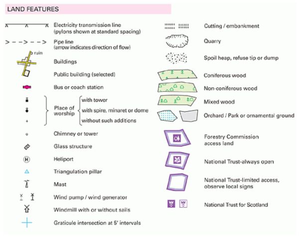
Learn the symbols for the features that make good landmarks, such as: churches,
windmills, masts, electricity pylons and chimneys. Make sure you remember the
difference between a church with a steeple and a church with a tower. In some
parts of Sussex you can have about 8 churches in view at one time, so it helps
to be able to tell them apart.
Learn the symbols for the different types of environment, like woods, marshes,
fields etc.
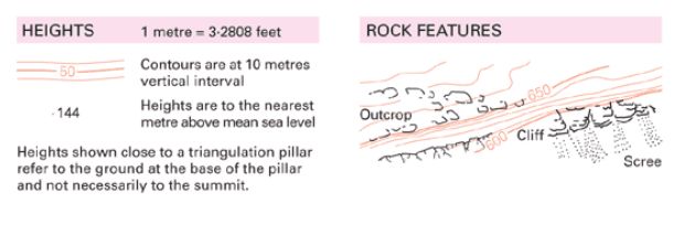
As you can see, contour lines are always the same vertical height apart (check
your map for the actual measurement),
so the closer together they are, the steeper the incline.
Click here
for more help with contours.
You also need to understand the symbols for public transport and roads.
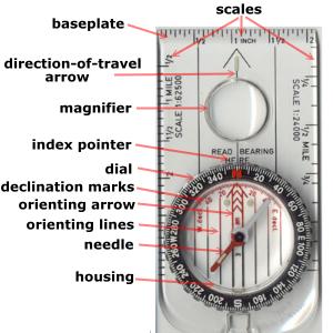
Using a compass.
Most people agree that the best type of compass for hiking is the Silva type.
Acquaint yourself with the different parts of the compass so that the
instructional video (below) make more sense.
This video explains how to use a compass in combination with a map.
Taking cross-bearings from two landmarks so that you can find your position on a
map.
When you take the sighting, use the same eye every time and close the other. If
you are right-handed, then use your right eye to do the sighting. It's easier to
remember it that way.
You can draw the lines using either side of the compass, it doesn't make any
difference but if you use a biro on a normal map it won't come off. Buy yourself
a chinagraph pencil instead.
Our tips
If you're going to be walking in Sussex then you'll generally be using well-marked, well-trodden footpaths, which of course are much easier to navigate than the wild moors and mountains of Scotland, for example. However, the principles are the same wherever you go, so gain experience of navigation on safe ground before you go venturing out to the mountains or the North Pole. For these
jottings therefore, we're assuming that you're going to be walking in Sussex (and so you should too!)
Study your pre-planned route on the map before you venture out, making sure that
you're able to cross obstacles like railway lines, streams and rivers where you
want to. Only the larger-scale Explorer maps show the small foot bridges (FB)
over streams, which is a very handy thing to know when you are planning a route. Look for landmarks on the map that will aid your navigation when you're
out in the field.
When you know your starting position on the map (either by taking a crossbearing
or because you already know where you are), when you've aligned the map to
north, and when you've found the direction you want to go in, you'll find that
navigation is a fairly simple process of following your progress on the map and
making sure you take the correct turns.
Problems can arise when you get confused about the scale of the map in relation
to what you can see around you. You need to keep looking at the aligned map and
comparing it to what you can see. If you're walking down a footpath and you need
to take the second footpath on your left that heads north, then make sure you've already gone
past the first footpath. That sounds straight forward, but if you're chatting and
looking at other things, then you can easily miss the first signpost (which may
be hidden anyway) and end up taking
the wrong path. Check with your compass that the footpath is leading you in the
right direction. Along many of the wooded paths in Sussex you can't see any
distant landmarks,
so you have to keep an eye on where you are. Remember that distances on the
map are two-dimensional and a mile of steep incline will appear to be a much
shorter distance on the map. Therefore, one of the first lessons you need to
learn is - how far is a mile (or kilometre)? When you get this knowledge firmly planted in your
subconscious you'll find navigation a far easier prospect.
You may find that footpath signs are not always immediately visible,
due to: overgrown vegetation, decay, breakage, vandalism etc, so you sometimes have to
be a bit of a detective to figure out where they are and in which exact
direction they are pointing. You'll find a lot of different
types of signage are used along the same footpath, so don't convince
yourself that you're looking for a wooden sign pointing the way when it may just be
a small metal disc. This is where a pair of binoculars can come in very handy.
You may become a bit daunted by some of the places that public footpaths actually
take you through. They can send you through; private gardens, farms, factories, stables,
airfields, MOD land... you
name it! Don't worry about this at all, if the footpath sign says you can go
there: then go there! Just make sure you stick rigidly to the footpath, respect people's property and privacy,
and closely follow the
Countryside Code at all times. People who have footpaths going through their
property are very used to seeing confused walkers scratching their heads and are
usually very friendly towards them, so don't panic. If in doubt, ask!
The simple truth is, that the more you just go out and try navigating, the
easier it gets. Sure, every now and then you'll go the wrong way, everybody
does, but if you regularly check with your compass that you're going in the
right direction, then you'll soon discover your mistake and rectify it. In
Sussex it doesn't really matter if you get lost - you'll nearly always end up
somewhere with a pub within 5 miles!
Have fun.