Sussex Scrapbook
~
Nature walks throughout the year
Amberley to Arundel (4 miles, 2.5 - 3 hours) and back to Amberley via Burpham
(7 miles ~6 hrs). Total walk = 11 miles, ~ 9 hours.
Ordnance Survey Landranger map 197: Chichester & The South Downs.
This is a perfect walk
which takes in everything you could possibly need on a day's hike in Sussex: a
river, woods, the rolling Downs, churches, a cathedral, castles, pubs... you can
even do some shopping in Arundel.
Much of the land has farm animals on
it or is private land or is a conservation area, so dogs need be kept on leads
I'm afraid.
The times indicated for
the walk include stops for food, photography, enjoying
the nature and views, exploring the churches and basically taking a very, very
relaxed attitude. You may well be able to do it in half the time, but do you
really want to? Give yourself plenty of time by getting to Amberley station as
early as you can, and just take your time and enjoy it.
Take note: The Duke's land (Arundel Park) is
closed to the public on March 24th every year, apparently for 'legal'
reasons. I don't know what that means, but there you go!
Please take the time to
read the
Countryside Code for yourself. This tells you about the law and your
responsibilities when out in the countryside.
For lots more help and
advice, visit our
Hiking Tips and Links
pages.
1. Start at Amberley
train station (TQ026 117).
2. Walk down the hill past the telephone box
3. Cross the B2139 and head LEFT along the pavement.
4. Staying on the right-hand side of the road (the safer side to walk on), cross the stone bridge over the
river Arun in single file. Take great care and use the cut-outs in the bridge to dodge the traffic.
5. Immediately the bridge wall ends, cross the road back to the other side, climb the stile and
take the footpath along the right-hand bank of the river. There may be horses
here, so keep the dog on a lead.
6. It tends to be a little bit muddy along the next bit but don't worry about
that, it soon stops. Follow the footpath all the way along the river until you eventually see a wall on your
right side. You are now on the
Monarch's Way which will take you to Arundel, but
just to be sure, I will describe the rest of the route for you.
7. Keep following the wall until you come to a metal kissing gate - go through the
gate. You are now on the Duke of Norfolk's land. (1.5 hours from start)
8. Turn left and follow the path upwards.
9. At the top, follow the footpath sign right and a little further on bear left
(signposted). Continue up.
10. You will soon come to some fantastic views and a great spot for a snack.
Please don't pick any of the flowers (they are all protected), and
remember to take ALL of your lunch litter home with you.
11. The footpath continues diagonally across a field to the right of the woods
(follow the direction indicated on the sign post).
12. Follow the sign posts over the top of the Downs and over the stiles (if you
go through a gate in this section, then you've gone the wrong way).
13. When you come down steeply to a junction of 5 tracks, take the one that goes
straight on and uphill.
14. At some woods you come to a gate with a stile. Take the stile, turn right
straight away and go up through the trees
past the sign that says
"Beware galloping horses".
IMPORTANT! If someone at this point asks you to stay where you are for a moment,
then please do as you're asked. Many of the Duke's race-horses gallop past the exit of this footpath and it's important that they're not spooked by a walker coming out
of the woods in front of them. Oh yes, it's important that you're not trampled
too!
15. When all is clear, cross the cinder track, walk past the triangular tower and down
(left) the long tarmac drive through the estate.
16. Pass through the kissing gate at the estate entrance and down to the end of
the drive.
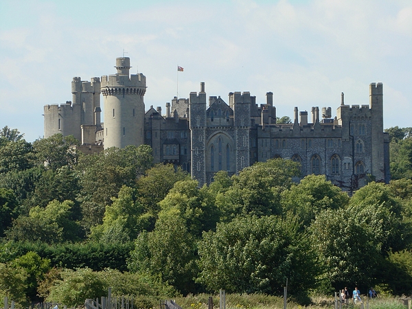
17. Turn left on the main road and walk down past the cathedral, St Nicholas' Church,
Arundel Castle and down into the high street. The churchyard is a good place to stop for
a spot of lunch. (2.5 - 3 hours after start)
You can now get the train or bus back to Amberley if you want, but why not continue? Trust us, you'll love it, and yes, of course you can make it!
18. Follow the castle
wall down through the high street and down to the river.
19. Cross the bridge on the left-hand side pavement (Queens Street) and take the
Monarch's Way immediately left after the bridge. The path goes straight on
through what looks like a little private car park and then back along the river.
20. You go over a further stile and then through a kissing gate.
21. Eventually you come to the railway line which you need to cross, over to the white
house opposite. TAKE GREAT CARE ON THE RAILWAY!
22. At this point you leave the Monarch's Way by taking the next footpath on the
left just after the white house (the signpost is on the R/H side of the road), which goes between the white concrete cones, down the gravel drive and
along the shady path.
23. Go through the next kissing gate and keep going in the same direction
and parallel with the railway line.
24. Go over a stile and go diagonally across the field.
25. Now there is a footpath left that takes you over a stile, parallel with the
railway again and up to the raised river bank.
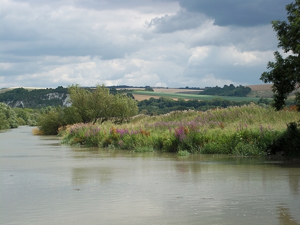
26. Turn right (east) and walk along the river, which is mostly reed beds in
this section.
27. Over another stile and up the steps that are straight ahead. This path takes
you past the George & Dragon pub, across the cricket ground and up to Burpham
Church. (~5 hours after the start)
28. Out the back of the church, in the corner of the churchyard, the footpath
continues over a low wall.
29. When you get to the small tarmac road turn left. Go straight on at the next
junction towards "High Barn".
30. The High Barn is a large flint building and just beyond it the footpath we
want goes right and follows a chalk track upwards.
This area is known as
The Burgh and is a conservation area. There are always things to be seen up here
but you have to keep your eyes well peeled. The landowners ask that all dogs must be kept on leads as
there are many ground-nesting birds.
31. Keep going straight on in the same direction (NE) on the Bridleway.
32. Straight on onto the Public Right of Way (check the signposts).
33. Eventually you will come to a large metal gate (that is usually wide open)
and a footpath right. IGNORE THIS PATH but take the next bridleway left, west
along a little track.
34. Continue straight on the bridleway and NOT the Restricted Byway that goes
left.
35. Shortly you will come to the South Downs Way, but before you continue left
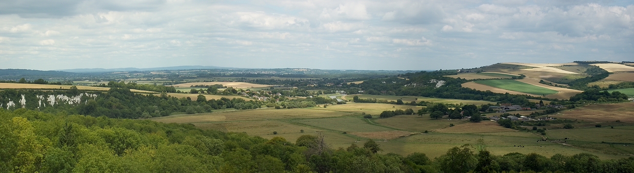
(west) on it, cross it, go through the gate opposite and go sit on the high spot
to your right. The view here on the top of Rackham Hill is superb.
36. Go back onto the South Downs Way and head west as mentioned previously, this
will take you through a gate and then steeply down to Downs Farm.
37. Follow the SDW signs straight on down the small track to the right and
continue on down to the tarmac road.
38. Turn right then bear left following the SDW signs all the way back down to
the B2139.
39. Cross the road and turn left and you will be back at Amberley station. (9
hours after start)
If you enjoy this walk then you will definitely enjoy the shorter Beachy Head walk.
If you follow one of our guides then we would love to hear how you got on. Visit our Guestbook and tell all.