Sussex
Scrapbook ~ Wildlife walks throughout the year
Sunday 4th May - Saturday 10th May
Lake District, Cumbria
We'd been meaning to get back to the Lake District together for about 4 years (I did my ML training there in 2013) but it was only a couple of months ago that we decided we were definitely going to do it. We booked an 18th Century cottage in the tiny village of Penruddock, 5 miles West of Penrith which would serve us well as a base for the mountains we wanted to climb. The cottage had sheep fields on either side of it and views of Great Mell Fell and Blencathra.
Monday 5th May 2014
Exploring by bike
90 miles
The first day we decided to do some exploring by bike, taking in the local village of Dacre and its church, the town of Pooley Bridge at Ullswater, the waterfall known as High Force and, to finish off, we thought we would test out the Harley on the steepest road in Britain - Hard Knott via Wrynose Pass.
.JPG)
The wonderful, spirit-raising view from our bedroom. Lambs bleating were our
alarm clock every morning.
Such a difference from car alarms, aircraft and police sirens.
.JPG)
Clouds we don't often see in Sussex due to the lack of the mountains required to
form them - Altocumulus lenticularis.
.JPG)
Dacre church
.JPG)
These strange statues in the graveyard (there are 4, one at each corner) are
known as the
Dacre bears and are famous for being totally inscrutable!
.JPG)
The pier at Pooley Bridge.
.JPG)
Aira Force
.JPG)
A Dipper near the falls. We watched it swimming and diving for small
invertebrates.
.JPG)
High Force just up the valley from Aira Force.
.JPG)
Approaching Hard Knott from Wrynose Pass. You don't see many Harleys with 16"
apehangers and pillions trying this route.
.JPG)
Hacking around the countryside.
Tuesday 6th
May 2014
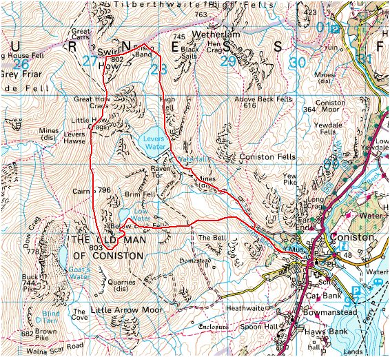
The Old Man of Coniston
9.5km
A
Hewitt, Marilyn, Nuttall
and a
Wainwright
![]() This
was our first mountain day of this trip and our target was the Old Man of Coniston (803m)
via Swirl How (802m). I intend taking the scouts up here in August when we come
to the Lake District for Summer Camp so this was a good opportunity to check it
out.
This
was our first mountain day of this trip and our target was the Old Man of Coniston (803m)
via Swirl How (802m). I intend taking the scouts up here in August when we come
to the Lake District for Summer Camp so this was a good opportunity to check it
out.

.JPG)
Off we go!
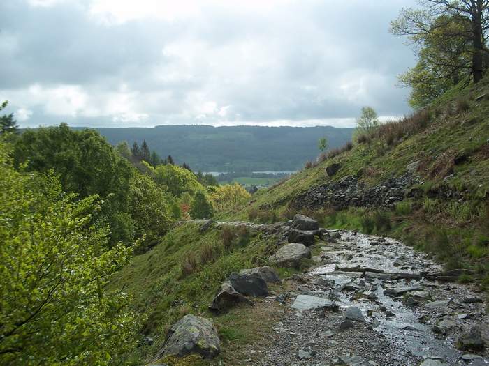
Following the beck, complete with waterfalls, through a small wooded section and
out into open land.
.JPG)
Along the beck and up to
Coniston Coppermines Youth Hostel.
.JPG)
A very difficult path up to the tarn, made up of small rocks. Very tricky
underfoot.
.JPG)
Levers Water half way up. Time for a cuppa.
.JPG)
Not many folk around but this guy crossed the path ahead of us.
.JPG)
A very nice section up between small crags up and up to the col (arrowed)
between Swirl How and Black Sails (745m).
.JPG)
Then it's a bit of crag climbing along Prison Band to get up to Swirl How.
.JPG)
Note the person climbing up centre right for a sense of scale.
.JPG)
796m and the view of the distant cairn at
the Old Man.
.JPG)
A bit further along and we can spot the winding route down from the Old Man which we will take
later.
.JPG)
Gill surveys the view of our ascent route
and Coniston from the summit of The Old Man (803m).
.JPG)
The way down is steep and rocky but very interesting with mine workings of all
kinds.
.JPG)
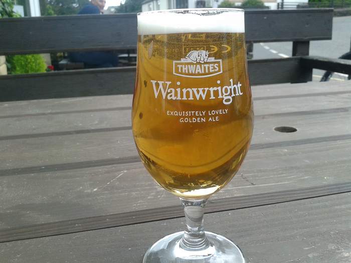
Our amber reward back at Coniston village
and a toast to AW.
Wednesday 7th
May 2014
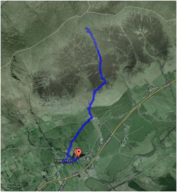
Blencathra via Hall's Fell from Threlkeld
A
Hewitt, Marilyn, Nuttall
and a
Wainwright.
An attempt on Blencathra (868m) via Hall's Fell, otherwise known as Narrow edge. I though I
might have been asking too much of Gill to get up here on this difficult ridge
and unfortunately I was right. A mixture of strong winds, rain, bad visibility
and a terror stricken wife meant that we had to call it a day at about 790m.
Mind you, after the difficulty of this ascent she will be much happier about
doing other ones in future. I still intend getting her to do Striding Edge
sometime which
is probably far easier than this.
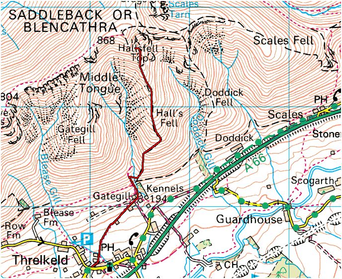
So close to the top yet so far!
.JPG)
This insane looking edge was to be our
route up. I hadn't let Gill know quite just how insane it really was.
I though it would be a nice ... surprise!
.JPG)
First a very steep moorland walk
.JPG)
Which quickly becomes a very rocky
walk/climb through crags.
.JPG)
Parts of the route have a rough path but finding the passage through is very
difficult.
.JPG)
The path disappears in parts and becomes tricky climbing which is quite
frightening to someone not used to it.
By the time we got to the pinnacle ahead Gill had had enough. The weather was
also deteriorating fast. So we descended back down to the pub.
There's always another day!
Thursday 8th
May 2014
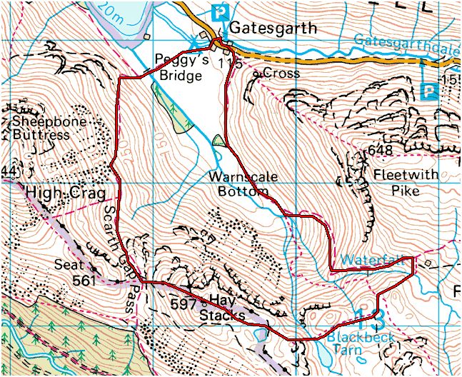
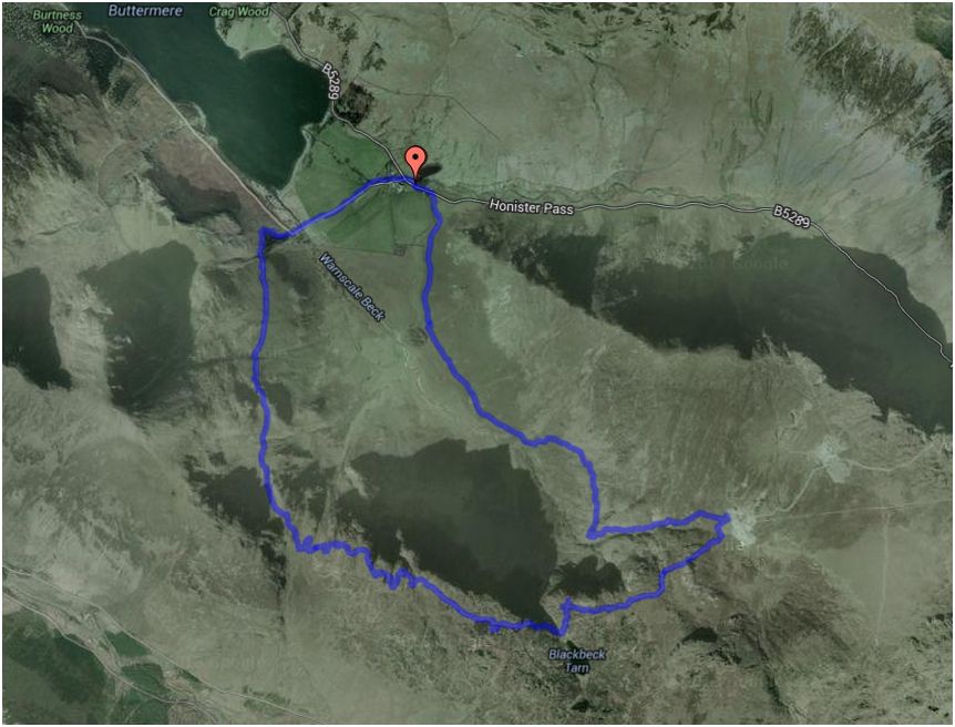
Hay Stacks from Gatesgarth
7.5km
A
Wainwright.
After yesterday what was required was a much easier ascent of a much friendlier mountain - Hay Stacks (597m). This was Wainwright's favourite mountain and his ashes were scattered by his widow beside Inominate Tarn near the summit. This is a beautiful climb which involves a bit of scrambling. A couple passed us as we were having some tea just before the crags and from up ahead we heard lots of wailing and a couple of small screams. Not very encouraging for Gill but when it came to it she found it quite bearable - matched to yesterday anyway! There is a way around the crags without climbing but who wants to do that? Possibly Gill.
.JPG)
Scarth Gap is our first objective on the way up and marks the point where the
crags start.
We had only just started off when we heard a Cuckoo calling from a small copse.
.JPG)
The initial climb is simple and very pretty with views of Buttermere and streams
pouring down the hillside.
.JPG)
A Wheatear keeps an eye on us.
.JPG)
A chance of some really fresh water from a waterfall.
.JPG)
Gill gets to Scarth Gap and she's still smiling.
.JPG)
The first crag (and the source of the screams).
.JPG)
On the top of the second crag and only one more to go.
.JPG)
The view back down to Buttermere with Crummock Water in the distance.
.JPG)
As you gain the peak you get this incredible view across the whole summit area.
.JPG)
The way down is just as exciting but without any scrambling.
.JPG)
.JPG)
Here you can see our path back down the valley on the flank of Fleetwith Pike
which follows Warnscale Beck
back down to Gatesgarth and the bike.
.JPG)
On the way down on what looked like a boring path from a distance. It was
anything but!.
.JPG)
A look back up to the top of Hay Stacks.
.JPG)
Right at the end of the walk we manage to spot the Cuckoo. Result!
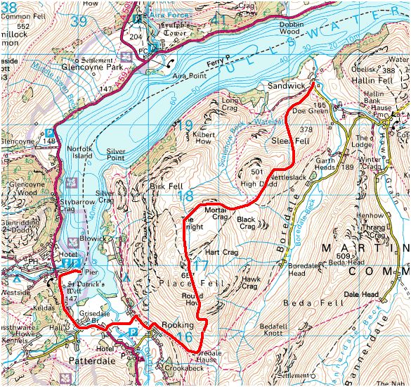
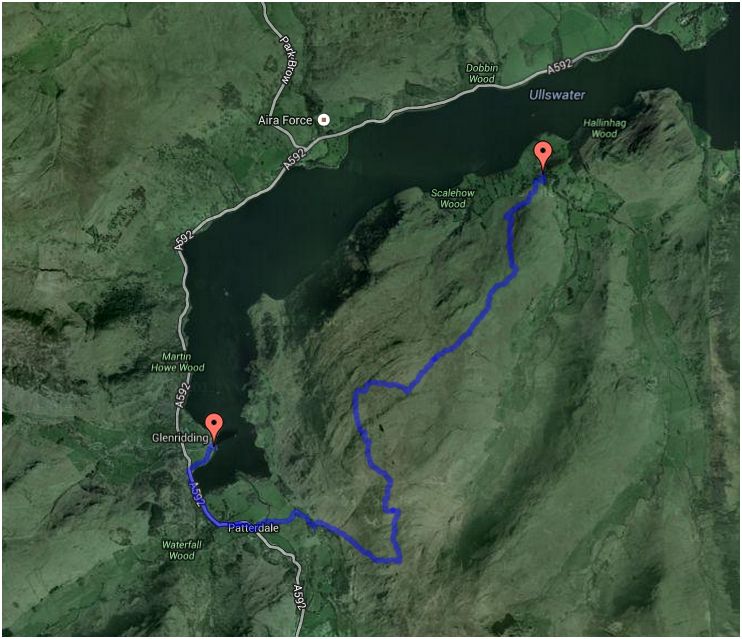
Friday 9th
May 2014
Place Fell
9km
A
Hewitt, Marilyn, Nuttall
and a
Wainwright.
We decided to
do a hill that was a fair bit easier and a fair bit lower and which would also
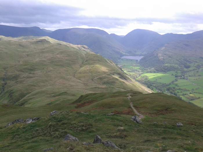
allow us to take a boat back to the bike, so we chose Place fell which gives great views of Ullswater and Helvellyn. We decided to start from a tiny place called Sandwick which is made up of 2 houses and a farm.
Our route wandered around the side of Sleet Fell (378m) and then up onto a high
ridge past High Dodd (501m). We had our lunch in a ruined sheepfold and then
took a route that took us out by Mortar Crag and The Knight (another crag) which
also gave amazing views including Striding Edge on Helvellyn. From there we
yomped cross-country up to the summit of Place Fell (657m). The rocky path back
down to Patterdale was great fun and very scenic and we even managed to get to
Genridding Pier in time for the last boat.
To get back to the bike we had a couple of miles to walk around Hellin Fell via
a lakeside path through Hallinhag Wood which was all mossy and green.
On arriving back at the bike I found that I'd lost the keys - DOH! We had to pay
£55 for a taxi to take us back to the cottage for the spare keys and then to
bring me back to the bike.
.JPG)
We leave the bike at Sandwick (centre) and head off up the side of Sleet Fell.
![]()
.JPG)
Looking back along the ridge over Sleet
Fell.
The cairn in the distance (arrowed) is on Hellin Fell and on the other side of
that is Howtown where the boat will deliver us later.
.JPG)
Gill mounts The Knight... oo er!
.JPG)
Helvellyn summit (with snow) and in front, leading up to the top is Striding Edge.
The way down to Patterdale.
.JPG)
Glenridding pier is in view just across
the water.
.JPG)
.JPG)
The area we'd walked over seen from the
middle of Ullswater.
.JPG)
A small walk through Hallinhag Wood back to the bike.
.JPG)
And there she stays until I can get back with the keys. What a horrible way to
end our walk and our holiday.
At least we are both safe and well and ready for the next time.
Take the time to read
the
countryside code for yourself and please stick to it at all times.